Old growth forests, charming harbours, spectacular beaches and eclectic communities are what make the Salish Sea Coastal Route an escape from the everyday. The overall mileage of this route is approximately 565 km (350 mi) and includes 4 BC Ferry crossings and can be done in 4 days, but once you start travelling this route, you’re going to want to stay longer. We recommend taking at least 5 to 7 days to really experience life on the coast.
The Salish Sea Coastal Route takes you from Vancouver up the Sunshine Coast dotted with small seaside communities, stunning inlets and with magnificent views across the Salish Sea. A short ferry ride transports you over to Vancouver Island from Powell River to Comox, south through the Cowichan Valley, a Foodie’s paradise and on to Victoria, the capital of British Columbia.

Section 1: Vancouver to Horseshoe Bay
Directions: From downtown Vancouver travel north on Highway 99 (BC-99 N) via the Lions Gate Bridge to North and West Vancouver and join up with the Trans Canada Hwy 1 heading towards Horseshoe Bay.
Estimated Driving Time: 30 minutes (21 km / 13 mi) from downtown Vancouver to Horseshoe Bay and the BC Ferries terminal.
Where to Camp: For campgrounds and parks available in the Vancouver area go to Camping & RV in BC and search under Vancouver BC. For other communities in Metro Vancouver search under the community name required.
Things to Do:
Grouse Mountain – For spectacular views of Metro Vancouver, a trip to the top of Grouse Mountain in North Vancouver is a must. Take the Skyride gondola straight up and enjoy a lumberjack show, visit a grizzly bear refuge, go zip lining or for even more breathtaking views, head up the Eye of Wind, a wind turbine with a viewing pod at the top!
Lonsdale Quay – Featuring a fresh food market full of local products, an international food court, specialty shops, restaurants and more, Lonsdale Quay is a fantastic place to spend an afternoon. Located at the water’s edge in North Vancouver, the Quay offers a stunning view of Vancouver’s skyline, both during the day and at night. And be sure to climb the observation tower to the “Q” for a bird’s eye view of Burrard Inlet.
Section 2: Horseshoe Bay to Gibsons Landing via BC Ferry
Board one of many sailings from Horseshoe Bay to Langdale and enjoy breathtaking scenery during the 40-minute voyage across Howe Sound to the Sunshine Coast.
Directions: Upon arrival on the Sunshine Coast, disembark and follow Marine Drive into Gibsons Landing.
Estimated Driving Time: 12 minutes (6 km / 4 mi) from Langdale Ferry Terminal to Gibsons Landing.
Where to Camp: For campgrounds and parks available on the lower Sunshine Coast go to Camping & RV in BC and search under Gibsons or Sechelt. For other communities on the Sunshine Coast search under the community name required.
Things to Do:
Sunshine Coast Museum & Archives – At the Sunshine Coast Museum you’ll find a fascinating collection of material from all over the Sunshine Coast region, including maritime, pioneer, First Nations and the local natural history of the area. Fans of the long-running “Beachcombers” TV series, should check out the collection of “Beachcombers” memorabilia.
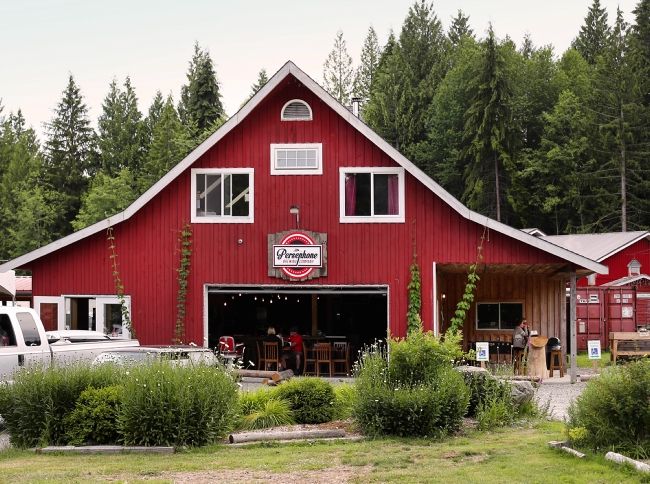
Persephone Brewing – Named for the log salver boat in the long-running TV show The Beachcombers, Persephone Brewing really sets themselves apart as a craft brewery. They take the process a step further by growing their own hops and food crops. Enjoy a flight of beer, choose your favourite and fill your growler. Kids are welcome.
Gibsons Landing – The scenic seaside village of Gibsons Landing acts at the gateway to the Sunshine Coast. Surrounded by mountains and ocean, its historic working harbour is alive with charm & character. Stroll down Molly’s Lane for a meandering streetscape of antique shops, galleries, bookstores and restaurants.
Section 3: Gibsons to Sechelt
Directions: Head north on Sunshine Coast Highway (BC-101N).
Estimated Driving Time: 30 minutes (23 km / 14 mi) from Gibsons to Sechelt.
Where to Camp: For campgrounds and parks available on the lower Sunshine Coast go to Camping & RV in BC and search under Gibsons or Sechelt. For other communities on the Sunshine Coast search under the community name required.
Things to Do:
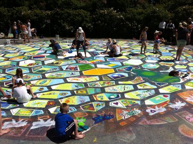
Roberts Creek – A short distance beyond Gibsons lays Roberts Creek, a picturesque, laid-back community. Stop by the General Store for an ice cream and visit any of the talented, local artists who make this community home. Don’t miss the Roberts Creek Community Mandala, the town’s most famous work of public art. Recreated annually by residents and visitors, the mandala is a beautiful example of the area’s creative expression and artistic roots.
Sechelt Nation Totem Poles – Take a self-guided walking tour around Sechelt and visit an impressive collection of totem poles erected by the Sechelt First Nations. Considered contemporary art in the tradition of the First Nations, the poles have representations of animals and mythical creatures, each of which has significance for the pole creator.
Farmers Market – The Sechelt Farmers Market is the largest on the Sunshine Coast and is packed full of garden-fresh produce, unique art, jewelry, fresh seafood, photography, knitting, toys and so much more. Every Saturday from early April, to the end of September.
Read this blog that includes information on this area:
Exploring Sechelt on British Columbia’s Sunshine Coast
Section 4: Sechelt to Egmont
Directions: Continue following the Sunshine Coast Highway (BC-101N) north.
Estimated Driving Time: 60 minutes (59 km / 37 mi) from Sechelt to Egmont.
Where to Camp: For campgrounds and parks available on the lower Sunshine Coast go to Camping & RV in BC and search under Pender Harbour or Egmont. For other communities on the Sunshine Coast search under the community name required.
Things to Do:
Smuggler Cove Provincial Park – Located in Smuggler Cove Provincial Park is one of the prettiest trails on the Sunshine Coast. This 4-kilometre trail is suitable for all abilities and is especially good for kids! The trail starts in dense rainforest and after a short walk you reach a series of elevated boardwalks that cross over a bog. The bog is home to beavers and their work is evident all along the trail. Before long, the trail changes to rocky bluffs, dotted with Arbutus Trees and spectacular views of Georgia Strait and Welcome Passage.
Boat Tour of Pender Harbour – Take a sunset cruise of the waters surrounding Pender Harbour and learn about the fascinating history of the area. The waters are calm and protected and the cruise is a wonderful opportunity to see this special community from the water. Learn about First Nations settlements, the logging and fishing eras, spot wildlife and see some amazing examples of West Coast architecture.
Hike to Skookumchuck Narrows – Hike the easy 4 km trail to the Skookumchuck Rapids, where you’ll have a chance to witness the incredibly turbulent water. Whirlpools clash as 200 billion gallons of water surge through the narrows connecting Sechelt and Jervis Inlets on a 3-metre tide. Visitors are often rewarded with a show by daring kayakers challenging the rapids.

Section 5: Egmont to Powell River via BC Ferry
Directions: Board one of many BC Ferry sailings from Earls Cove to Saltery Bay and continue north along the Sunshine Coast Highway (BC-101N).
Estimated Driving Time: 1 hour, 40 minutes (includes 50 minutes onboard the ferry) (56 km / 35 mi) from Egmont to Powell River.
Where to Camp: For campgrounds and parks available on the upper Sunshine Coast go to Camping & RV in BC and search under Powell River. For other communities on the Sunshine Coast search under the community name required.
Things to Do
Hike the Sunshine Coast Trail – The Sunshine Coast is home to Canada’s longest hut-to-hut hiking trail and at 180 km from end-to-end the Sunshine Coast Trail can be a challenge in summer or winter. But you don’t have to hike the entire 180 km, in fact, there are many access points all along the trail that enable experienced hikers to enjoy sections of the trail year round.
Powell River Historic Townsite – One of the few places in Canada designated a National Historic Site; this town site is a remarkably preserved example of a single-industry, company-built town from the early 20th century. The townsite was built as a garden community with some 400 Westcoast Craftsman style homes, and 30 institutional and commercial structures dating between 1910 and 1930. Self guided and guided tours are available.
Visit Historic Lund – At the north end of Hwy 101, is the historic fishing village of Lund. Home to the Historic Lund Hotel and a collection of charming shops and eateries, Lund is also the gateway to Desolation Sound.
Kayak Desolation Sound Marine Park – The regions’ only Marine Provincial Park, Desolation Sound is 8,449ha/20,878ac of protected boating waters which more than provides an isolated area of safe paddling waters. Crystal clear waters allow for views of marine life and it’s not uncommon to come across whales, sea lions, deer and eagles. Guided kayaking tours are available.
Read this blog that includes information on the area:
Powell River, BC: Insulated by Nature
Section 6: Powell River to Parksville via BC Ferry
Directions: Board one of many BC Ferry sailings from the Little River-Westview Ferry Terminal to Comox on Vancouver island. Then take the scenic route and follow BC-19A S.
Estimated Driving Time: 2 hour, 55 minutes (includes 90 minutes onboard the ferry) (40 km / 25 mi) from Powell River to Comox. Drive (80 km / 50 mi) from Comox south to Parksville.
Where to Camp: For campgrounds and parks available in the Comox and Parksville areas, go to Camping & RV in BC and search under Comox or Parksville. For other communities on Vancouver Island search under the community name required.
Things to Do:
Comox Air Force Museum – Comox is home to a Royal Canadian Airforce Base, CFB Comox, and the fascinating history of Coast Canadian Military Aviation. In addition to interpretive displays and artifacts, flight enthusiasts will especially appreciate the Heritage Air Park, where vintage aircraft are on display.
Climb a Mountain – From late June through September, hikers can hop the chairlift (1588m elevation) at Mount Washington and head to the summit to discover the unique flora and fauna found in the Mile High Alpine. Feel free to hike from the bottom if you’re feeling energetic. Mount Washington is also the gateway to Strathcona Provincial Park, British Columbia’s oldest provincial park and the largest on Vancouver Island.
Horne Lake Caves – Head deep underground and experience the magic of spelunking. Horne Lake Caves Provincial Park offers visitors the opportunity to explore these naturally occurring caves. Some of the caves are open for self-exploration, but to get the full experience take a guided tour. Tours range from family-friendly to “extreme” adventure.
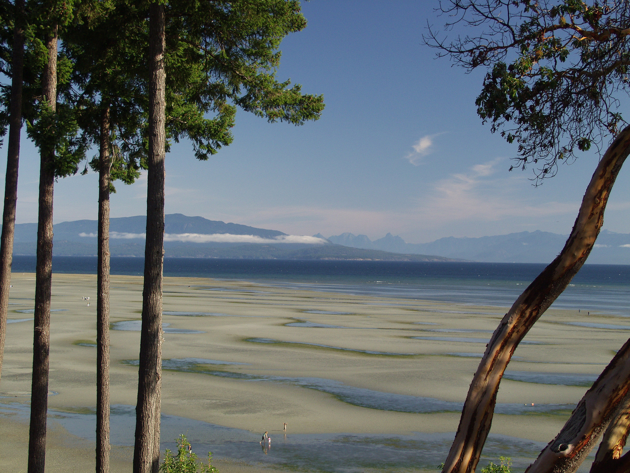
Do some Beachcombing – The beaches of eastern Vancouver Island are a beachcombers dream come true. At low tide, firm sandy beaches stretch for miles and are rich with sand dollars, hermit crabs, periwinkles and clams. And, from October to May, keep your eyes peeled for glass floats and glass sea creatures, hidden along the shoreline from Deep Bay to Nanoose Bay by “float fairies”.
Section 7: Parksville to Duncan
Directions: Take the scenic route and follow BC-19A S alongside the water.
Estimated Driving Time: 1 hour and 5 minutes (90 km / 56 mi) from Parksville to Duncan.
Where to Camp: For campgrounds and parks available in Parksville go to Camping & RV in BC and search under Parksville. For other communities on Vancouver Island search under the community name required.
Things to Do:
Goats on the Roof – A visit to Parksville isn’t complete without a quick side trip to Coombs to visit the Goats on the Roof, grab a gelato and browse the Old Country Market. These four-legged “employees” can usually be found on the roof on the market, happily munching away on the grass.
The Nanaimo Bar Trail – While in Nanaimo, pick up a copy of the Nanaimo Bar Trail brochure and take the sweetest self-guided tour on the Island. With 30 different stops you’re sure to find the Nanaimo Bar of your dreams.
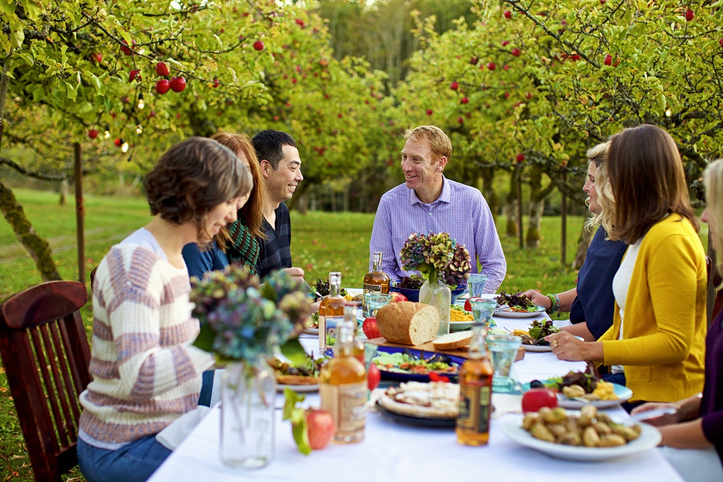
Visit Merridale Cidery – Appropriately tucked away in an apple orchard, Merridale Cidery is open daily for tours and tastings. Merridale crafts their 100% pure juice and ciders from heritage varieties of English and French Cider apples grown on-site. Take a tour and learn all about the production of cider and spirits, then enjoy a guided tasting.
Read this blog that includes information on the area:
A Slice of the Mediterranean in the Heart of Vancouver Island, BC
Section 8: Duncan to Sidney (via Victoria)
Directions: Follow Trans-Canada Hwy/BC-1 S to the Patricia Bay Highway /BC-17
Estimated Driving Time: 1 hour and 15 minutes (80 km / 50 mi) from Duncan to Sidney.
Where to Camp: For campgrounds and parks available in Sidney go to Camping & RV in BC and search under Sidney. For other communities on Vancouver Island search under the community name required.
Things to Do:
Totem Tour – Take a self-guided (or guided) walking tour of the over 40 totem poles that the City of Duncan has erected in recognition of their strong connection with the Cowichan Tribes. Guided tours are offered daily from June to September, and can be arranged other times of the year. Or simply follow the yellow footsteps and take the tour on your own.
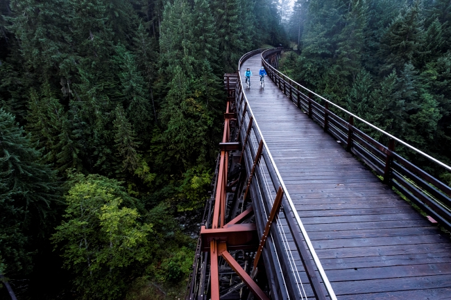
Walk or ride the Historic Kinsol Trestle – One of 8 trestles along the Cowichan Valley Trail, the Kinsol Trestle is by far the largest and most impressive. The trestle is one of the tallest free-standing timber rails trestles in the world and hikers and cyclists are welcome to cross and enjoy the views of the Koksilah River, some 44 metres below.
Royal BC Museum – Take a trip through British Columbia’s past with a visit to the Royal BC Museum. Discover artifacts and explore realistic dioramas, complete with Woolly Mammoth and marine life. And be sure to take a stroll through the cobbled streets and shops of Old Town.
Harbour Tours – Hop on board a Victoria Harbour Ferry, from March to October, and discover Victoria from the water. 45 minute guided tours depart from the Empress Dock and take you past the Parliament Buildings, colourful floathome communities and First Nations territories.
Sidney Waterfront Walkway – Take a stroll along the seaside on Sidney’s fully accessible waterfront walkway. At 2.5 kilometres long, it’s a short walk with a spectacular view of Sidney Island and Mt Baker. Keep an eye out along the way for unique sculptures, which form an outdoor gallery, and the Sidney Seaside Sculpture Walk.
Section 9: Sidney to Vancouver
Directions: Follow BC-17 to Swartz Bay and take the Swartz Bay Ferry to Tsawwassen. From Tsawwassen follow BC-17 to BC-99 into Vancouver.
Estimated Driving Time: 3 hours (90 km / 56 mi) including a 1 hour & 35 minute ferry crossing.
