
Village of Radium Hot Springs, BC: A Great Place for a Fall Trip
With kids back to school, we decided to join the retirees and other seniors for some fall camping in the Kootenays. We started out from our home base in the Okanagan, headed south through Osoyoos to Rock Creek and stayed one night at Kettle River Provincial Park. We have camped there a lot but always in the heat of the summer, so it was nice to enjoy some cooler weather. From there, we headed east to Moyie Lake Provincial Park; located 20 Kilometres south of Cranbrook it had been years since we camped here and was nice to return. Both campsites had lots of space, and both were open until early October. Another welcome surprise was that since my husband had turned 65 this year and we were camping outside of the peak season; we were eligible for the seniors’ half price camping rate.

Radium was our next destination. We lived in Invermere when we were first married, and it is always nice to return to our old stomping grounds and see how things are changing. Radium still had the same welcoming feel, a mecca for outdoor enthusiasts young and old. Being that it was mid-September, we could sense that things were slowing down for the winter. We were immediately greeted by the bighorn sheep at the gas station as we pulled into town.

As far as RV accommodations go, we would recommend The Canyon RV Resort. We liked the flat treed sites with some right on Sinclair Creek, which can be viewed from the highway. From what I understand they close for the winter sometime in October, so check to make sure they are open if you are travelling later into the fall. We agreed with the great reviews we had read online and will definitely be back. For those travelling without an RV or planning to camp, there are also many cute motels as well as high-end hotels available in the village.

While in Radium we wanted to check out The Springs Course. It is one of two golf courses, the other called The Radium Course. The Springs is consistently rated as one of the best in BC. It is located between two high mountain ranges, the Purcells and the Rockies. Its panoramic views of the Columbia River kept us in awe as they did many years ago when golfing there.
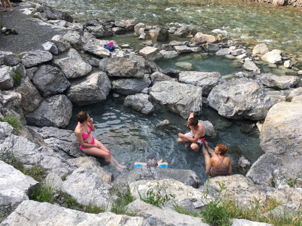
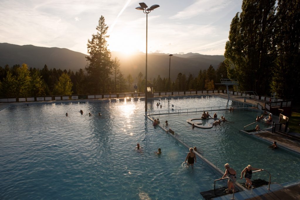
Next on the list, hot springs!! Just east of the Village of Radium is the entrance to Kootenay National Park and Radium Hot Springs. The hot springs and surrounding lands have long been used by Indigenous peoples. Radium Hot Springs got its name when trace amounts of Radium were found in the water. Parks Canada has a good overview of its history on their website.

A soak in the hot springs was at the top of my list; needless to say, it was beautiful. Another benefit of travelling in the early fall was that there was plenty of room to park and not too many people in the pool. It really has not changed much over the years. We used to love going to the pools in the winter when it was snowing, a real perk of living in the area. Another favourite memory of living in the area was going to Fairmont Hot Springs which is just about 30 minutes south. We used to soak in the hot springs after a day of skiing at the mountain just above them.

I have also heard that the Sinclair Canyon Trail network has some good trails with views of the creek, educational signs and rest areas with benches. We didn’t get a chance to do any of those this trip but saw one of the trail-heads just above the hot springs. It was hard to pass this one up, but we need a reason to come back!
After leaving Radium we ventured further into Kootenay National Park along scenic Highway 93. Many of the campgrounds were closed at that time of the year; they seem to have different fall closing dates, so good to check before arriving. We went for a great walk in Marble Canyon which is about 90 kilometres from Radium. The trail is short (about a kilometre), with neat rock formations as it winds its way along Tokumm Creek through the narrow gorge and across many bridges.

I can’t really describe how awe-inspiring and beautiful the mountain scenery is in Kootenay National Park, but it is definitely a great place to explore at all times of the year, including the fall.
TIP: If you find this blog interesting why not subscribe to the enewsletter and never miss another story!
For places to camp in this area and elsewhere in British Columbia go to the Camping Map.
Share your BC travel and camping photos using hashtags #campinbc #explorebc.
Wonder and Awe – Yoho National Park in BC’s Kootenay Rockies
If you are looking for stunning steep mountains, spectacular waterfalls and turquoise glacial waters, Yoho National Park is the place to visit!
After travelling from the village of Radium through Kootenay National Park along scenic Highway 93, we ventured into a camping area we had not visited in the past, beautiful Yoho National Park.

From the Marble Canyon Trail in Kootenay National Park, we continued north on Highway 93 for 18 kilometres to the intersection of Highway 1 (also referred to as Castle Junction). Curious as I am, I had to find out why it is known as Castle Junction. It is named after Castle Mountain, so-called for its castle-like appearance which is a few kilometres away with a popular hiking trail. This area is in Banff National Park, so by the end of the day we had travelled through three national parks: Kootenay, Banff and Yoho. From Castle Junction, we travelled west along Highway 1 for a half hour until we entered Yoho National Park.

Our first stop was the Yoho National Park Visitors Centre to pick up a visitor’s guide and a park pass. The visitor centre is located at the entrance to the town of Field, less than 10 kilometres from the eastern park entrance.
After getting our very-affordable pass, we visited the small town of Field, with a population of less than 200, and which is the only community in the park. Field was established in the 1880s as a settlement for the Canadian Pacific Railway (C.P.R.) workers and is home to various historic buildings from this era. There are also a couple of places to eat and a few shops. I loved wandering around the pottery shop, Velvet Antler Pottery & Gallery, the Siding Cafe where we picked up some supplies, and we made plans to come back for dinner at the very popular Truffle Pigs Bistro.
Nearby, we had a choice of two campgrounds: Monarch and Kicking Horse. Both were located close to each other and off the same highway exit, which made it easier to check them both out. Monarch was smaller with 44 sites but located close to the highway, so we opted for Kicking Horse which was just up the road with 88 sites. Kicking Horse was a great campground, central to most of the day trips we made, it had a nice new shower house, and we found the campsite to be very quiet. Even though there were quite a few campers set up, it seemed deserted during the day because most people were off on day-trips.

Just up the road from our campsite was Takakkaw Falls; we planned this well as we checked in and left our trailer at the campsite and then drove to the falls. There are no long vehicles/trailers allowed on the road because of the switchbacks and there are warnings that vehicles over 23 feet need to reverse to get around the corners. Apparently, the day before, the road was closed as a longer bus got stuck on one of the switchbacks. The falls were a short 20–30-minute walk, busy with visitors, and absolutely beautiful! After the falls we followed the trail in the opposite direction towards the hike-in, backcountry campgrounds: Laughing Falls (6.5 kilometres) and Twin Falls (8.6 kilometres).

Another trip was to the learn more about the C.P.R. Spiral Tunnels. Just a short drive on the highway east from our campsite was the lookout. Built in the early 1900s, the tunnels are a pair of rail loops (inside the mountain!) designed to help trains navigate the steep incline which was more than twice the allowed grade.
Another short trip took us to the Natural Bridge, located on the road to Emerald Lake. It is a limestone rock formation created by the erosion of the stunning glacial water of the Kicking Horse River.

Our last visit in Yoho National Park was the iconic Emerald Lake, surrounded by beautiful turquoise, glacial water and the President Mountain range. We intentionally arrived by 9:00 am to beat the crowds. Keep in mind, it was September so earlier in the summer might be a better time. We easily found a parking spot but by the time we left, the cars were lined up over a kilometre down the road. We hiked around the lake (5.3 kilometres) which took about an hour; the first half (if heading left from the parking lot) was a wide-open trail alongside the lake; after reaching the end of the lake and crossing the bridge, the trail becomes less developed with lots of slippery spots and roots to climb over. But it is still an easy hike.

After the trail, we grabbed a coffee and snack and found a nice spot beside the lake to enjoy the magnificent view! We didn’t see any swimmers (swimming is not for the faint-of-heart, it is so cold even in the summer), but there were lots of people who had rented canoes. We were also excited to see a couple who had just got married and were having their wedding photos taken on the bridge.
To finish off our September camping trip, we stopped at Canyon Hotsprings before heading home to the Okanagan. We had a long leisurely dip in their natural hot spring pool. We timed this well because it was the last day they were open before closing for the season. They have two pools, with warm water piped in from a source 3 kilometres away. A great, relaxing way to finish up our late summer/early fall camping season. We are looking forward to our next trip!
TIP: If you find this blog interesting why not subscribe to the enewsletter and never miss another story!
For places to camp in British Columbia go to the Camping Map.
Share your BC travel and camping photos using hashtags #campinbc #explorebc.
Camping in British Columbia’s West Kootenays: Checking out three great campsites
Camping in the West Kootenay’s is a great way to explore the area and visit communities like Nakusp and Burton. So in July 2020, we visited three campgrounds near or on the shores of Arrow Lake and the town of Nakusp.
KBR Campground
2 km north of Nakusp lies KBR Campground with 40 campsites. This campground is in a great location for those who want to explore the area, through hiking, shopping, eating out in Nakusp, or relaxing in the hot springs across the road. A new addition this summer is their koi pond. KBR is a great location for travellers on the go.
Three Islands Resort
15 km south of Nakusp is Three Islands Resort. Located on Summit Lake, this campsite is a paradise for campers with easy access to the lake, lots of local ATV trails and very helpful owners. What we liked about this campground was the lovely beach and boat launch plus lots of choice for sites, whether you are looking for tenting, full service or lakeshore sites.

Burton Historical Park
36 km south of Nakusp is the community of Burton with its rich history. Founded in 1895, Burton was originally a gold rush town. Its destiny dramatically changed with the signing of the Columbia River Treaty (between Canada and the United States) and the building of the Keenleyside Dam in the early 1960s which controlled the flow of water in the river for hydro-electric power. This was a very traumatic time for many of the long-time residents in the area who were forced to leave or relocate when the valley was flooded.

Near the original town site is the RV Park we stayed at; it is called Burton Historical Park. This park is a real gem, sitting on the shores of Arrow Lake. There are lots of sites along the lake, as well as great amenities such as hot showers, great beach access and a sani-dump. The Seniors Trail (named in honour of the local seniors group who developed it) leads from the campsite south along the lake to the site of the old cemetery. The campsite host at the park shared with us that in the early spring when the water levels are low, you can still see remnants of the old foundations.

While we were camping at Burton we walked up the road to the Burton Bean, a farm stand with lots of local seasonal fruits and vegetables along with all kinds of neat treasures from local vendors and artisans. If you are looking for eggs, this is the place to go. This has to be the cutest chicken yard I have ever seen, full of happy hens!

A little further up the road we stopped in at Burton City Cider to try some of their local cider and their yummy pizza.

We then meandered across the highway, to the community of Burton. Even though many of the original buildings on the lake were either burned or torn down, we walked past many that were relocated including the old general store which is now closed.
If you are looking for great camping, a beautiful part of BC and plenty of things to do, check out the Nakusp area and make it a destination for your next summer camping trip.
TIP: If you find this blog interesting why not subscribe to the enewsletter and never miss another story!
If this area interests you, check out our drive:
Mountains, Lakes & Rivers in the West Kootenays and Boundary Country
For other campgrounds in this area or elsewhere in British Columbia check out the Camping Map
Share your BC travel and camping photos using hashtag #campinbc, #BCNice, #explorebc
Soaking it up at Lussier Hot Springs, Kootenay Rockies, BC
This year we set out to explore as many hot springs in the Kootenays as we could squeeze into a four-day road trip. We started with Radium and Fairmont in the East Kootenay area and finished up with Ainsworth and Halcyon, both in the West Kootenays. All of these are developed hot springs, but one that we had at the top of our list was Lussier Hot Springs. These natural springs are located in Whiteswan Lake Provincial Park. Back in the early 1990s we lived in Windermere, just south of Invermere, so this was a place we visited often and always loved it.
To get to Lussier, head south from Invermere (on Highway 93/95) and just south (4.5 kilometres) of Canal Flats, turn east onto the Whiteswan Forest Service Road. Be super careful on the road as this is an active logging area and the big trucks come up and down pretty fast. The gravel road was easily accessible with my little Mazda 3 but would definitely recommend a 4×4 in the winter. Just past kilometre 17, you will see the parking lot for the hot springs on the right side of the road.

There is a short hike down to the hot springs from the parking lot/outhouses. The trail is not difficult but it may be a bit steep for anyone with mobility issues. New, since we used to come in the early 90s, are the outhouses which double as change rooms. Depending on the time of the year, you may find that you have the hot springs to yourself and other times it can be quite busy. This trip we met a family from Holland exploring the area.

As you get close to the river, you will pick up on the sulfur smell which is common to most natural springs. There are three pebble bottom pools, with the hottest pool being further away from the creek. I can remember going there in the winter; it is absolutely beautiful to see the steaming water with the snowy background. If it’s cold, it does not take long for ice crystals to form on your hair and if you are really brave, you can take a dip in the frigid Lussier River. This trip, we did not dip in the river; it was a beautiful warm day, so the pool closest to the river was comfortable enough to stay in; whereas in the winter, it is pretty cold. If you look closely, you can see the hot bubbling water flowing into the pools from between the rocks.
If you continue on the forest service road to kilometre 25, you will find Whiteswan Provincial Park with the beautiful Whiteswan and Alces lakes. Reservations are not available but there are 114 campsites located at the five campgrounds either along the river or lake.
Alces Lake which is the closest to Lussier at kilometre 21, is a good lake for swimming and fishing for rainbow trout, with 28 sites, pit toilets and lakefront sites. The other campgrounds are located at Packrat Point, Inlet Creek, White River and Home Basin.

Another beautiful area is the remote Top of the World Provincial Park, with the trail-head at kilometre 52. We have done some amazing hikes in this area.
After your visit to Lussier, if you are still looking for more hot springs, check out the Radium Hot Springs about 45 minutes north and Fairmont Hot Springs about 30 minutes north on Highway 93/95, both worth a visit.
For campgrounds and RV parks in the Kootenay Rockies and elsewhere in British Columbia go the Camping Map.
Share your BC camping pictures using hashtag #campinbc.
5 Fun Family Adventures Near Wasa Lake in the East Kootenays, BC
Wasa Lake is the warmest lake in the Kootenays and is a popular summer camping destination. This Provincial campground has 104 sites (66 of them are reservable), an amphitheatre for parks talks, nature trail, kids (or adventurous adults) bike park, as well as washrooms with flush toilets and showers. Wasa Lake itself is a short walk or bike ride through the campground and has sandy beaches, a playground, boat launch and grassy picnic areas.
Although the weather was warm when we visited it wasn’t hot, sunny beach weather, so we opted to explore the local area and discovered some amazing places to visit just a short drive away.
Here are five fun things to do in the area.
Explore Wasa Lake Provincial Park
We spent the better part of a day just exploring our surroundings, especially enjoying the small bike park located within the campground. It’s perfect for younger riders with small jumps, obstacles like planks, bridges, rocks, and small ravines to challenge their skills. Also, be sure to check BC Parks website for contests and things to do. You can also download a pamphlet for Jerry’s Nature Quest which includes some fun games to do in the park.
Visit Fort Steele
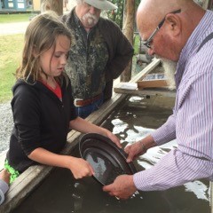
Fort Steele is a heritage town located about 20 minutes drive from Wasa. The town has heritage houses and businesses to explore, gold panning, a bakery, an ice cream parlour and a few restaurants as well. We spent several hours exploring the town and had a great time. Be sure to take a ride on the steam train if you go – it’s a fun way to step back in time.
Visit Cranbrook
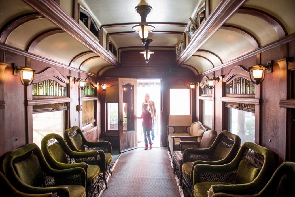
Cranbrook is home of the Canadian Museum of Rail Travel. At one time this town was the major train hub for the area and is now home to a unique rail museum with restored train cars to wander through and explore. Cranbrook is the closest city to Wasa to restock your supplies and is one of the Kootenays major centres so you’ll find several large grocery and hardware stores, shopping in the mall as well as in the downtown core. It’s a great place to explore on days when the weather just isn’t on your side!
Hit a Hot Springs (or two)
Fairmont Hot Springs, Radium Hot Springs and Lussier Hot Springs are all close by. Fairmont and Radium are developed hot springs with several pools, change rooms, places to eat and lots of parking. They are both great options for the whole family with Fairmont being the closer of the two at just a short 45-minute drive away. Lussier Hot Springs is a natural hot springs, so you’ll have to park and hike in – no services, change rooms are available, it’s definitely for the more adventurous campers!
Bike One of the Loop Trails
Take one of the Loop bike trails and explore a bit more of the Wasa area. There are two bike loops to get you out of the campsite and exploring the area. The first: Wasa Lake Lions way, is a shorter loop that is a good walking trail as well, although at 8 km you’ll need to be sure you have good walking shoes on and water for the walk. It’s a paved flat trail, great for the whole family as even very young riders can manage this one. The second loop is the Lazy Loop bike path, and don’t get confused by the name…the path isn’t lazy – that’s the name of the lake the path takes you to. This route is 33 km round-trip and takes you up into the mountains to get there!
We had a great time at Wasa Lake Provincial Park and exploring the East Kootenays. We’re looking forward to a return visit next year.
To locate other campgrounds in this area or elsewhere in British Columbia go to the Camping Map.
Share your BC camping and travel photos using hashtag #campinbc
Pacific Rim National Park Reserve, BC is a Great Place to Visit in the Off-Season
One of the best parts of living in British Columbia is being close to both the mountains and the sea. BC has a lot of mountain-based national parks, but it also is blessed with a spectacular coastline – and none more spectacular than what you find in Pacific Rim National Park Reserve on Vancouver Island.

Pacific Rim National Park Reserve is made up of three units spread along the west coast of Vancouver Island. Long Beach, the unit furthest north is the most accessible and arguably the best known. It is named after the 16-kilometre long stretch of sand lining Wickaninnish Bay and offers abundant opportunities for beach-combing, storm-watching, and surfing. Further south, the Broken Group Islands section is made up of over 100 small islands and is a dream destination for beginner and advanced kayakers alike. Further south still, the West Coast Trail is a challenging 75-kilometre backpacking route not to be taken lightly.

Pacific Rim National Park Reserve is a popular summertime destination, but it should not be overlooked for an “off-season” getaway. In the winter, the Pacific Ocean is whipped in to a frenzy and the storm watching is second to none. No matter which season you plan your visit, you will find many things to see and do while you are there.
What to do
Highlights in Pacific Rim National Park Reserve include:
- Beachcombing: One of the best things to do in Pacific Rim National Park Reserve is beachcombing. Pack a picnic lunch and spend the day wandering the shores of Long Beach. Bring your dog, too. Long Beach is one of the only dog-friendly protected areas in Canada, however dogs must be on-leash at all times.
- Kayaking: With some advanced planning, kayaking the Broken Group is an adventure you will never forget. The Broken Group is rich in wildlife, including sea lions, whales, and bears. It is also home to unique coastal features including sea arches and sea caves.

- Kwisitis Visitor Centre: Pacific Rim National Park Reserve is on the traditional lands of the Nuu-chah-nulth people. At the Kwisitis Visitor Centre you can take in the spectacular views from the deck before heading inside to learn about the area through a variety of exhibits. After your time at the Visitor Centre, head out for a self-guided walk on the Nuu-chah-nulth Trail.
- Surfing: Numerous licensed operators work in Pacific Rim and without too much trouble you should be able to find someone who can hook you up with rentals and lessons. Don’t forget a wetsuit, the water is cold even on the warmest summer day.
- Storm Watching: Pacific Rim National Park Reserve is not only a summertime destination. In fact, from November to March the park comes into its own as a winter storm watching destination and is known worldwide for its huge waves.

In the Area
Tofino and Ucluelet have capitalized on their coastal location and proximity to Pacific Rim National Park and both offer a variety of activities and attractions. In Ucluelet, check out the Wild Pacific Trail for an easy coastal walk. My favourite section of the trail is the 2.5 kilometre Lighthouse Loop that takes you out to the 102-year old Amphitrite Lighthouse. In Tofino, consider joining a tour or hiring a charter and heading to Hot Springs Cove, a series of natural hot pools accessible only by boat or float plane.

Where to Stay
Camping in Pacific Rim National Park Reserve can be a bit tricky as there is only one campground within the Long Beach unit. The Green Point Campground offers 94 drive-in sites and an additional 20 walk-in sites. During the summer season, advanced reservations are a must if you want to stay in the park itself. A handful of private campgrounds are available in both Tofino and Ucluelet, but just like in the National Park, make a reservation ahead of time if you are travelling during the busy summer season.
Pacific Rim National Park Reserve offers a huge range of opportunities for exploration. From highly accessible and popular options in the Long Beach Unit to the extreme backcountry of the West Coast Trail, you are guaranteed to find something to suit whatever your heart desires. Keep in mind this park’s popularity when planning your trip. It can sometimes be a challenge to find accommodation on busy summer weekends and you will be greatly rewarded if you book your trip in advance. Don’t worry, though, with 16 kilometres of sandy beaches in the Long Beach Unit, you are sure to find a place that feels as though it is meant just for you.
If this area interests you, check out our drive:
From Coast to Coast on Vancouver Island: Vancouver to Tofino
TIP: If you find this blog interesting why not subscribe to the enewsletter and never miss another story!
For more campgrounds in and around British Columbia check out the Camping Map at Camping & RVing BC.
Check out more blogs in the National Parks & Historic Sites series:
A Primer to Canada’s National Parks in BC.
Explore Fort Langley & Gulf of Georgia Cannery Historic Sites and Check Out Some of BC’s Fascinating History
BC’s Gulf Islands National Park Reserve Offers Rich Opportunities for Exploring
BC’s National Historic Sites Offer a Glimpse into the Past – Here are 3 to Explore
Kootenay National Park, BC Offers Great Vistas, Hiking & History
Visit Mount Revelstoke National Park in August for its Stunning Vistas & Wildflowers
Yoho National Park, BC – A Jewel in the Canadian Rockies
Glacier National Park: A Special BC Destination
Pacific Rim National Park Reserve – A Great Place to Visit in the Off Season
Share your BC camping and travel photos using hashtag #campinbc #explorebc
There’s always somewhere to #CampinBC
Published: August 17th, 2017
Connect With Us